
Quarry Survey
Case Study
LiDAR Elevates Safety and Efficiency in Quarry Management
Introduction:
The Quarry, located in Horwich, Greater Manchester, faced a daunting challenge in its quarry management operations. The presence of an imposing cliff and fall hazard rendered traditional surveying methods unsafe and inadequate. In pursuit of enhanced safety, operational efficiency, and precision, The Quarry embarked on a transformative journey to harness the capabilities of LiDAR technology, facilitated by the Zenmuse L1 camera.
Client Overview:
Client: The Quarry
Location: Horwich, Greater Manchester
Industry: Quarry and Mining
The Quarry faced multifaceted challenges:
Safety at the Forefront: The quarry’s imposing cliff and fall hazard posed a constant threat, rendering traditional surveying methods impractical and perilous.
Operational Excellence: The Quarry aimed to optimize operational efficiency by judiciously allocating resources, effectively managing stockpiles, and strategically planning quarry activities.
Comprehensive Surveying Needs: The quarry required precise topographical data, grade plans, and buffer zone definitions to ensure secure and efficient operations.

Solution:
Our solution was rooted in the transformative potential of LiDAR technology:
Leveraging LiDAR Technology:
- The Zenmuse L1 camera, equipped with cutting-edge LiDAR technology, emerged as the linchpin of our solution.
- LiDAR Survey, utilizing laser pulses for precise distance measurements and 3D point cloud creation, transcended the constraints of conventional surveying methods.
Elevating Safety and Efficiency:
- LiDAR-based surveys enhanced safety by eliminating the need for personnel to operate near the perilous cliff’s edge.
- LiDAR-facilitated surveys expedited operations, resulting in augmented efficiency, reduced timelines, and cost savings.

Get Started Today
We're here to answer your questions and explore how our services can benefit your project. Don't hesitate to reach out to us via phone, email, or through our social media channels.

Implementation:
- The implementation of LiDAR technology via the Zenmuse L1 camera proceeded seamlessly:
- Our proficient team, equipped with the Zenmuse L1 camera, conducted routine site visits and flyovers, capturing exceptionally accurate LiDAR data of the quarry.
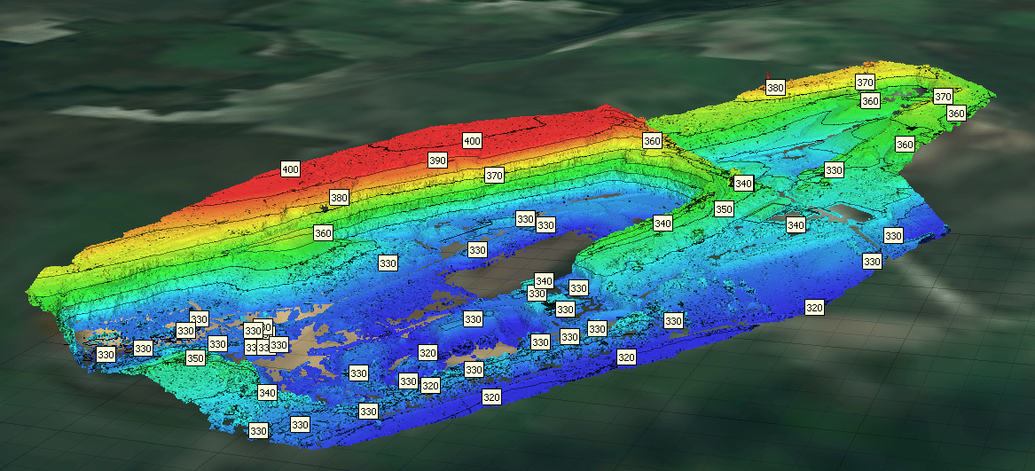
- The LiDAR survey data was meticulously processed to generate precise topographical maps, grade plans, and buffer zone definitions.
Deliverables
We successfully delivered a comprehensive set of invaluable surveying assets to The Quarry: LiDAR Data in LAZ Format: The LiDAR data collected by the Zenmuse L1 camera was efficiently delivered in LAZ format, optimizing data storage and accessibility. Topographical Maps in PDF: These comprehensive maps provided a clear view of the ground’s elevation and contours, delivered in PDF format for ease of reference and integration into quarry operations. Grade Plans in DWG: Essential for guiding grading operations, these plans illustrated the desired elevation of the ground surface. They were thoughtfully delivered in DWG format to seamlessly integrate with quarry machinery and software. Buffer Zone Definitions in PDF: These definitions effectively delineated restricted areas around specific features, ensuring the safety and protection of the quarry environment. They were conveniently delivered in PDF format for straightforward reference and implementation. The integration of LiDAR technology with the Zenmuse L1 camera has propelled The Quarry’s quarry management processes to an echelon of excellence. Safety, efficiency, and precision have been elevated through LiDAR-based surveying, positioning the quarry for sustained success within the mining industry. The Zenmuse L1 camera, with its LiDAR capabilities, has indisputably emerged as a transformative force within The Quarry’s operations, epitomizing innovation and progress in the realm of quarry management.
Contact
For more information please email p.harty@skyscansurveys.co.uk or call our Head Office on 0751-851-1623